
Yasugatake Nobeyama Highland Ultramarathon
Race report 18: 東の横綱 (Higashi no Yokozuna: Strongest in the East)

31st Hoshinosato Yatsugatake Nobeyama 100 km Ultramarathon (第31回 星の郷八ヶ岳野辺山高原100kmウルトラマラソン)
Before running this ultramarathon I wrote an article called Exploring the Nobeyama Ultramarathon Course. A breakdown of the course is in that article so if you want more granular details please check that article (people who want to run the Nobeyama Ultramarathon in the future may find both these articles useful). This race report will focus on my experience with the race.
I ran the Challenge Fuji 5 Lakes Ultramarathon last year and wrote a report about that one too. Since both the Fuji 5 and Nobeyama ultramarathons are managed by the same organizer, this report will follow a similar structure to the last one.
Logistics
When I ran the Fuji 5 I booked the race first and then booked my hotel and bus after. The main reason for this was that it was announced beforehand when the hotels for the event would become available. I intended to do the same thing this time but the day before I booked the race (in October) I noticed that a list of recommended hotels was already available and were open for booking. The day I realized this I went down the list calling every hotel until I eventually came to a place which had a shared room available. I booked the hotel for two nights (not knowing anything about my roommates) and then booked the race. (Booking the bus when it opened was no problem. I booked a one way bus with the intention of making my own way home after).
The day before the race
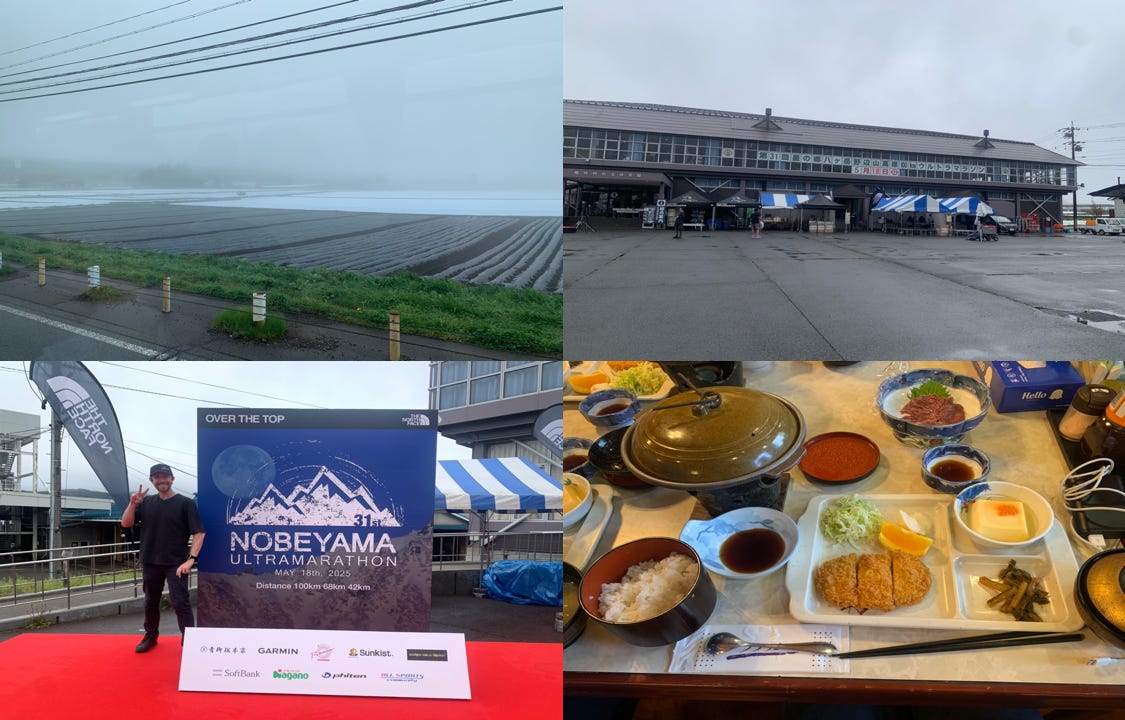
Fast forward seven months and on a rainy May day I hopped on a bus from Shinkuku for a three hour journey to Nagano. The bus ride itself was pleasant enough, and by the time we arrived in the Nobeyama area the rain had more or less stopped (but it was quite foggy).
There was a festival for the event right where we were dropped off but unfortunately the bus arrived as the festival was ending. I took some pictures then went to Nobeyama station (the highest railway station in Japan), then got taken to the hotel by shuttle bus.
I met my roommates (like last year they were relieved I could speak Japanese), ate dinner (馬刺 : Basashi (Raw horse meat)), went to the hot spring, got my gear ready then turned in before 19:00. Breakfast was at 02:30 and we were taken by shuttle bus to the start line before the race kicked off.
Race day breakdown
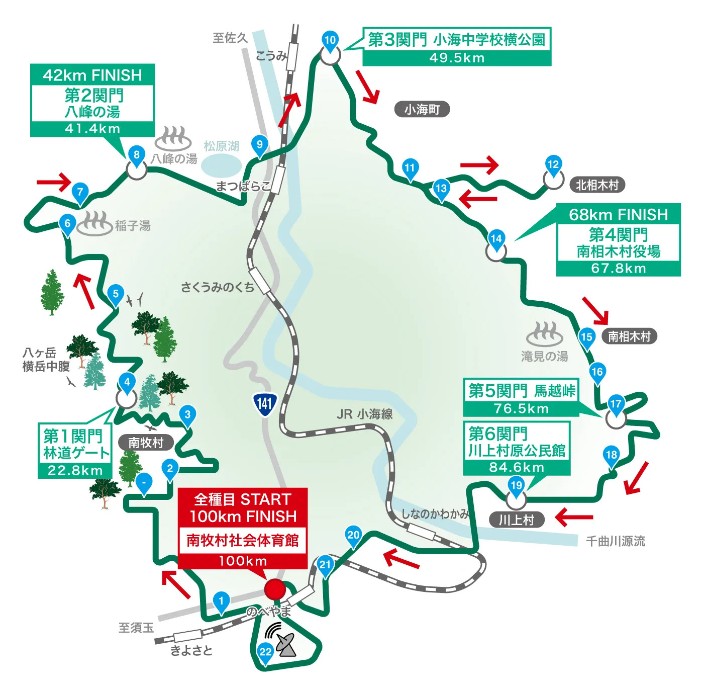
When I ran the Fuji 5 Lakes I based the main sections of the report around the lakes. Since Nobeyama is less well known than the Fuji 5 Lakes area, I’m separating this report by 関門 (kanmon: checkpoints). The checkpoints in these races are very strict. If you don’t make them in time you get a DNF (did not finish) status.
As with the previous report, I’m putting this report together using posts from 𝕏, photo metadata, and memory.
Start to Checkpoint 1 (0 – 22.8 km)
海尻側林道ゲート: Kaijiri forest road gate
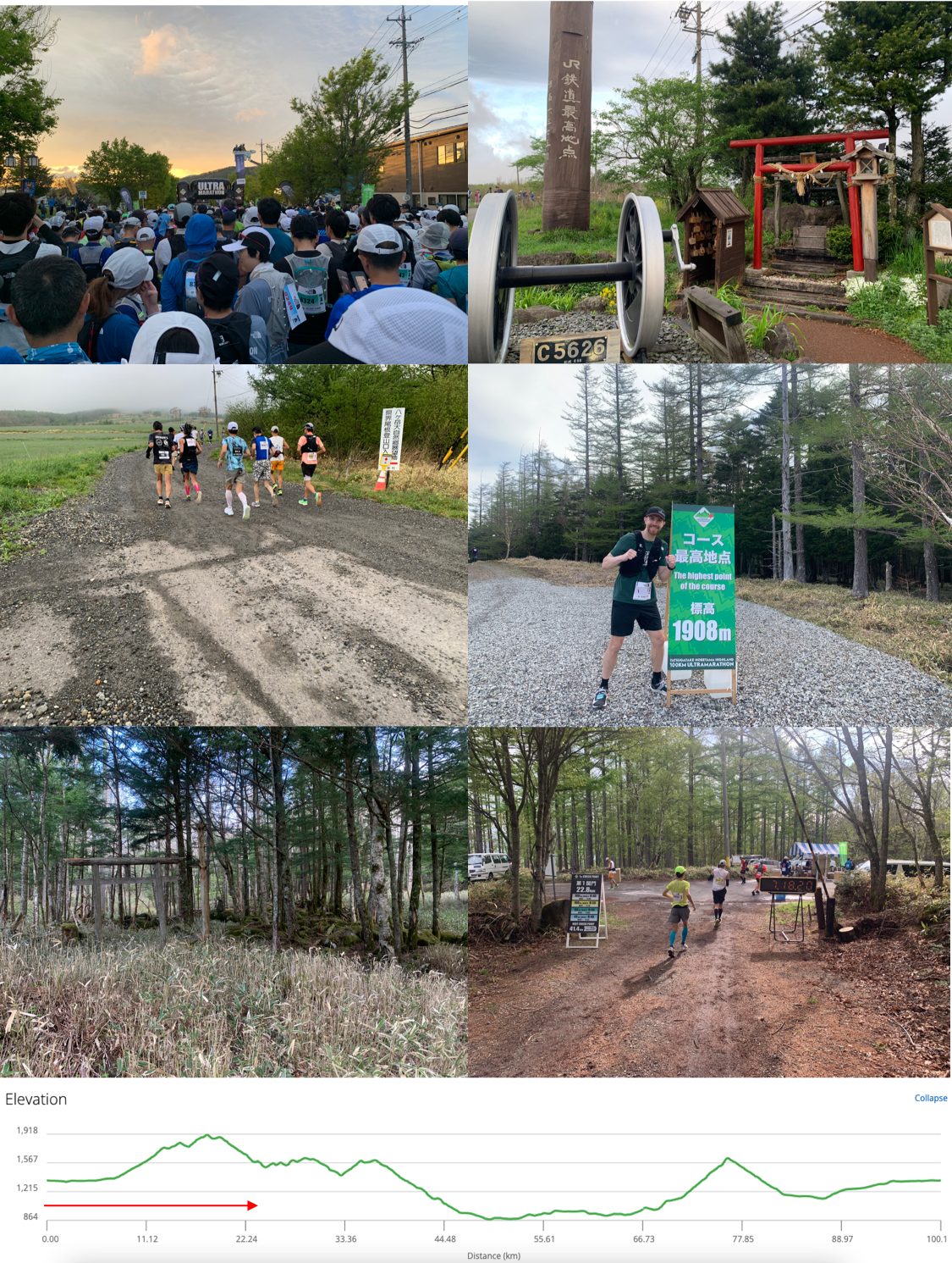
My wave began at 4:55 from the arch in front of 南牧村社会体育館 (Minamimaki Community Sports Center). I arrived at about 3:30 and ended up just hanging around for a while and talking to some of the other runners before I set off. I ended up talking to some other foreign runners but unfortunately I didn’t exchange contact details with them (please shoot me a message if you read this, guys).
I had all of the course data on my watch and ready to go. I set off Strava as a backup before the race started and as soon as 4:55 rolled around I started my watch. My watch then started crashing and rebooting over and over again, so I made the decision to just ignore all the data I prepared and go without watch navigation. This would mean I did the climbs by memory, but there was no other way to deal with it.
We started running through the streets and around the farms of Minamimaki village to a lot of cheering locals. It seemed like the whole community came out to support. There was an elderly gentleman waving to everyone who I gently high five’d on the way past (because I didn’t want to smack his hand too hard).
It didn’t take long until I came across the first aid station at 7.3 km. I was confused at first because this aid station was at 最高地点 (Saikōchiten: Highest point) despite it not being the highest point of the course (this point was at 1,375 m). The name for this area comes from it being the highest piece of JR railway in Japan. There was a marker, a shrine, a restroom, and a crowd of people (and dogs) cheering the runners on.
The course had been gradually increasing in elevation as we went along. Suddenly the road turned into an increasingly steep gravel path as we started running into the mountains. I knew there was a lot of climbing to do and the first mountain (approximately a 570 m climb) was literally just the beginning. As soon as I felt my heart rate starting to climb too high I slowed down and switched to power hiking. I’d then either count steps or use visual markers to do bursts of running followed by walking sections. There were quite a few people who were slow jogging the entire way up the hill, but my hiking with bursts of running had me going the same speed (if not a bit faster) as some of them.
Note: It can be quite easy to get pulled along by what other people are doing. Ultramarathons are more about self management than they are running. I knew I’d need to manage myself so that’s what I did.
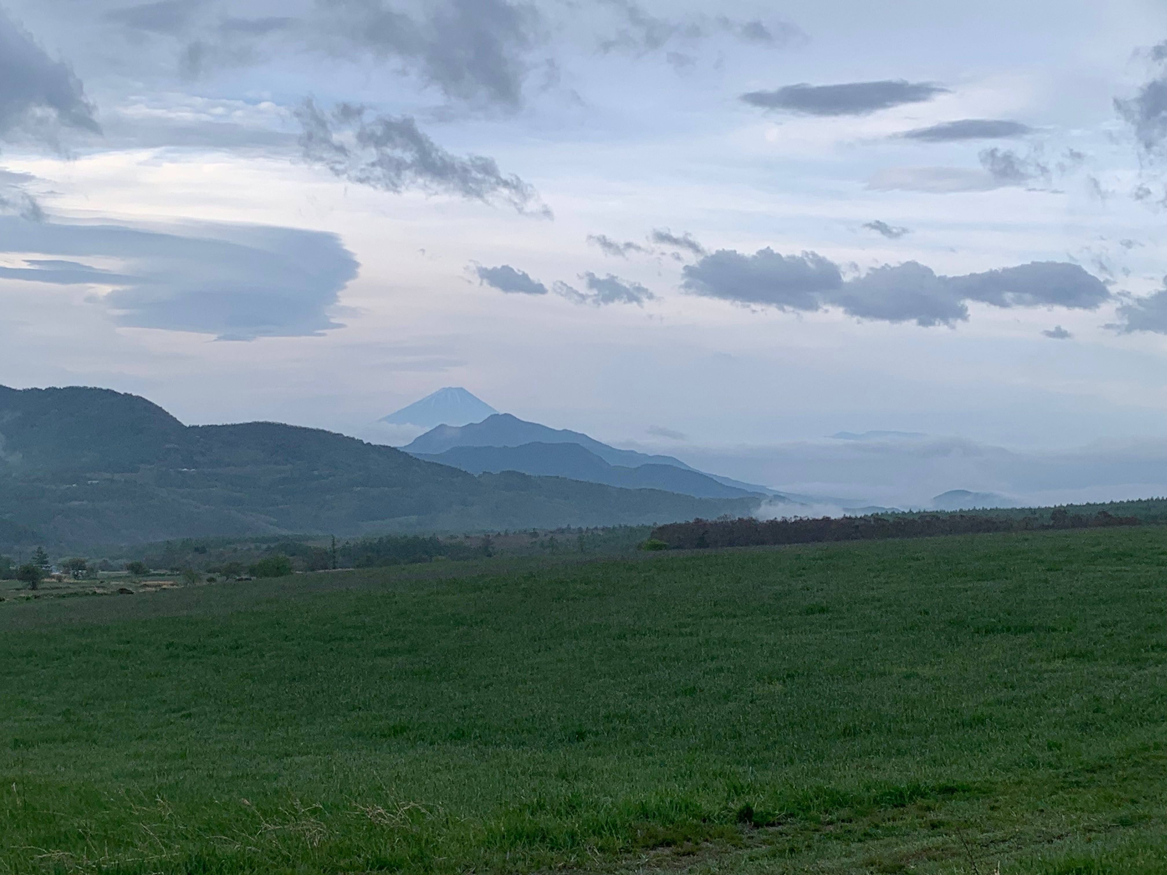
The mountains were beautiful. There were quite a few occasions on the course where I said to myself that if I don’t stop and take a picture I’d regret it. So I stopped a few times to take pictures including the Mt. Fuji picture above and an old 鳥居 (torii) in the woods. One thing I didn’t take a picture of (which I regretted) as a pile of snow that I saw at the side of the road, despite it being more than 20 degrees even in the mountains.
I kept slogging up the mountain until I reached the actual highest point of the course at 1,908 meters and then got ready for a big downhill segment.
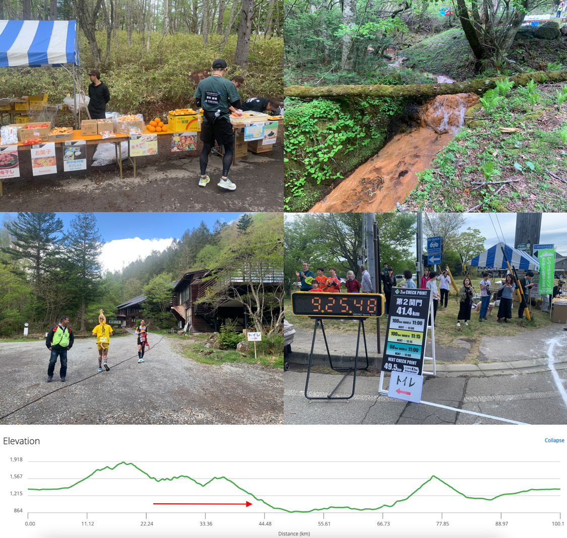
I running uphill is a bit of a weak area of mine, but I am very good at running downhill. I don’t try and slow my descent at all when running down hills and just let my weight and gravity take me. I ended up passing quite a few people that had passed me on the ascent. It was not pure downhill for this segment but I made it a rule for myself on this ultra that I would not waste downhill segments by walking. I was hiking the ascents, jogging the flats, and hard charging downhill. All this turned out to be a good strategy because I arrived at the first checkpoint at 海尻側林道ゲート (Kaijiri forest road gate) 1 hour 22 minutes ahead of the closing time.
I took note that the next checkpoint closed at 11 am, ate a bunch of fruit, drank some soup, and made sure to hydrate and take salt tablets before setting off to the next checkpoint.
Checkpoint 1 to Checkpoint 2 (22.8 – 41.4 km)
八峰の湯 : Happonoyu
The next section was a gravel road with a combination of ascending and descending. I continued to use my strategy of running as fast as I could downhill, jogging the flats, and hiking (with the occasional burst of speed) uphill. This strategy had served me well in the first part of the course so I planned to stick to it. I had some discomfort on my right heel but I did my best to ignore it.
I came into an aid station at 28 km and noticed they had dried apples. Of course I’ve eaten dried apples before, but these ones kept my attention for quite some time (possibly due to hunger) and I spent a good five minutes here just eating apples.
I ended up talking to another foreign runner (from Germany) around here and for the next section of the course we ran into each other again a few times. He was a much better climber than me but once again my downhill game had me passing a lot of people (including him, though we would meet again later).
At one point on the way to the next aid station I noticed a guy dressed in yellow with a giraffe on his head. I was sure I’d seen him before so I asked him if he’d run the Shizuoka marathon this year and his reply was, “Yea. That was me.” (There are not many people that run with a giraffe on their heads).
The next aid station (34.1 km) was at a mountain hot spring called 稲子湯 (Inakoyu). I did my usual refueling and was given some gels (which I ended up just carrying with me), and while I was checking out the scenery I noticed the giraffe runner head into the hot spring. I’d heard that some runners use the hot springs on the way, but personally I knew I wouldn’t have time to do it.
There was another climb, a small descent, then another small climb, followed by a huge downhill segment that would take us to the next checkpoint and the end of the 42 km race. The huge downhill section went from about 37 km (1,600 m) to about 49 km (880 m). Descending 720 meters over 12 km is my kind of terrain so I quite enjoyed this section.
The bulk of the 37 – 41.4 km section was on a grassy slope, which was really nice to run on in dry conditions (but may have been a nightmare if it was rainy). In this section I noticed a few people with 42 km number cards on, so I made sure to give some encouraging words as I went by.
I arrived at the second checkpoint (八峰の湯 : Happonoyu hot spring) 1 hour 35 minutes ahead of the closing time.
Checkpoint 2 to Checkpoint 3 (41.4 – 49.5 km)
小海中学校横公園 : Park beside Koumi Junior High School
I spent a bit of time at the Happonoyu aid station refueling, rehydrating, and chatting with some of the volunteers. Because this aid station was the end of the 42 km course (those finishers were sent a different direction to finish the course), I was thinking to myself that it might have been a good idea to have entered a shorter ultra. I still had more than half way to go and it was getting even hotter.
I ended up coming across my German friend at this aid station and we ended up running together and chatting for the next chunk of the race. He was on a business trip and was squeezing an ultra in while he was in the area. He told me a lot about the races he ran in Europe (most of them trail races), all of which sounded absolutely fantastic.
This section was downhill all the way. It was on roads and through small villages. Having just come from the first big mountain section of the course and into the main basin section, I could feel a big difference in the temperature. The mountain section had a bit of a cross breeze, but this section had absolutely no wind. I made a point of throwing cold water on myself whenever I reached an aid station.
When I got to the bottom of the hill I came to a park where volunteers were preparing 蕎麦 (soba) noodles for the (roughly) half way checkpoint.
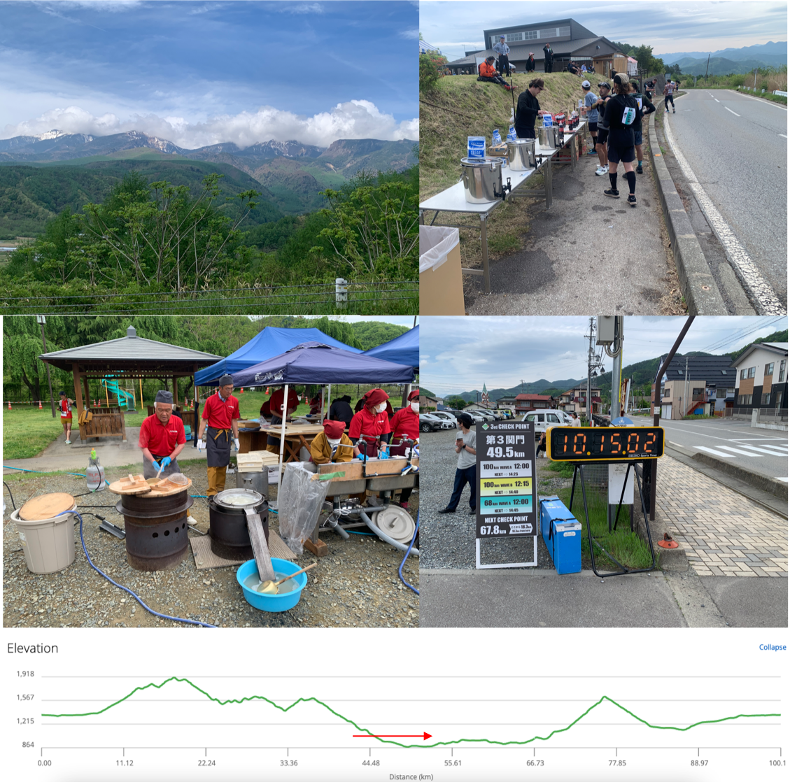
I arrived at the third checkpoint (小海中学校横公園 : Park beside Koumi Junior High School) 1 hour 45 minutes ahead of the closing time.
Checkpoint 3 to Checkpoint 4 (49.5 – 67.8 km)
南相木村役場 : Minamiaiki Village Office
This section was the last leg for the people running the 68 km course. I needed to keep pressing my advantage and my German friend needed a bit more time at the aid station, so I told him to take care of himself and ran on ahead.
A few hundred meters up the road I came across the actual halfway point of the course (50 km) by a bridge. It seemed a little anti-climactic but there was literally no room in that area for anything bigger than a sensor on the ground.
I ran along a country road for a while longer and came across the 川又バス停 (Kawamata bus stop) aid station at 54.1 km. I remembered this point from looking at the course map because at this point there is a hairpin in the course, meaning you will run by runners finishing the hairpin on the way in, then pass by runners entering the hairpin on the way out.
As I was running along I saw a running YouTuber and local hero, Ultra Runner Myaco (channel link here) running along and talking to her cameraman. I shouted some encouragement at her, and to my surprise she yelled, 「久しぶり」(Hisashiburi: long time no see), back at me. I’ve seen Myaco-San at many races before but I haven’t actually had a chance to speak to her. Still, the fact that a running celebrity remembered my face gave me a great boost for this section of the course. Which I needed because sometimes these hairpin segments feel like they go on forever.
The scenery in this part of the course was very nice. There was also some great support from the locals. It seemed like a really idyllic place to live.
I eventually arrived at 北相木村役場 (Kitaaiki Village Office) at the end of the hair pin, where I was met with a kiddie pool, an aid station passing out Shonan Gold Energy drinks, and frozen pineapple. Though I didn’t jump in the kiddie pool I did stand under a hose for a while to cool off. The pineapple and energy drink was much appreciated.
It was only after I left the village hall that I realized I’d been running a steady incline the whole way in and now had a downhill section until the end of the hairpin. This let me get a nice jogging rhythm going on the way out of this section.
I took a left out of the hairpin segment then started running in an area with new terrain. Some locals were out there cheering people on and one woman even offered me a small plastic bag filled with ice. I declined the bag of ice, but shortly wished I hadn’t done. (It may have been nice to have shoved it in my hat).
While running through a village section I started talking to another runner who was just about to finish the 68 km run. She was in pretty high spirits considering how close she was to the end of the run. She also told me that she had recently become a grandmother, so that was even more of an inspiration. I was pacing myself so I encouraged her to run ahead and finish the section since she only had 2 km to go and I had 44 km to go.
When I arrived at the next checkpoint it was a bit of a festival atmosphere. The end of the 68 km course was right next to the sensor I needed to run over to continue my journey. Just before running over the sensor I took a picture, but I realized as I was hanging around that the announcer was not just calling the names of the people completing the 68 km section, but also called out my name as someone who was supposed to be continuing the course. And there I was hanging around in front of the checkpoint. I realized my error, ran through the checkpoint (laughing at my own foolishness) and gave a wave to the lady I was running with just before.
At this point I ate a bowl of noodles, fueled up on whatever other fruit they had on offer, hydrated, and prepared myself for a massive climbing segment of the course.
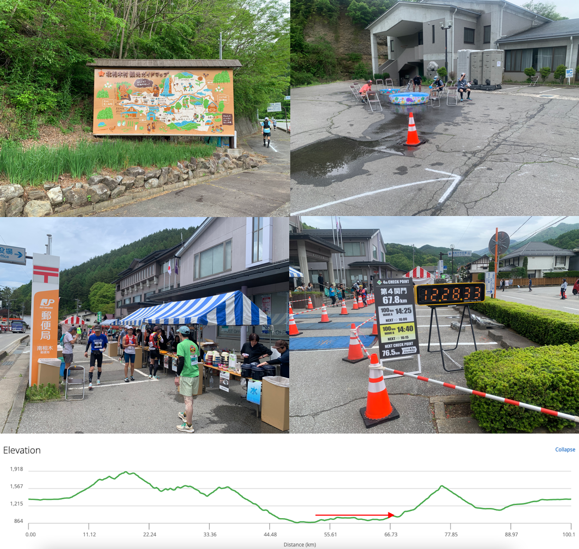
I arrived at the fourth checkpoint (南相木村役場 : Minamiaiki Village Office) almost 2 hours ahead of the closing time. Making good time.
Checkpoint 4 to Checkpoint 5 (67.8 – 76.5 km)
馬越峠 : Magose Pass
Right after this point I expected a big climb to start. I ran through some beautiful countryside with a slight incline before suddenly heading up a road that got very steep, very quickly. I knew from studying the course profile that the biggest climb of the course was here so I decided to stick to hiking up it as quickly as I could.
There was almost no one running in this segment of the course. The one guy that I did see running shouted, “I was refreshed by the hot spring,” as he ran by me. That wasn’t a translation, he shouted it in English.
The scenery was beautiful but the climbing felt pretty endless. When I got to 立原公民館 (Tachihara Community Center) (72.2 km) it looked to me like half of the aid station was at a 45 degree angle due to the incline. The race was clearly set up to provide additional support in these areas because the aid stations became more frequent.
After leaving that aid station I saw a guy with a black race number. People with black race numbers have completed the Nobeyama Ultramarathon more than 10 times. I caught up to him and struck up a conversation to ask him how far it was until the end of the climb. He gestured over in the direction we were climbing and said we need to run between that V shape in the mountains and then the main climb would be over. I could not see a V shape so I knew we still had a lot of climbing to do. This runner was in his 60’s and had completed the ultramarathon 18 times. I felt pretty confident that I would finish if I was keeping up with a veteran like this. (He said he’s aiming for 20 times but looking at how he was going I think he has more than that in him).
I reached the next aid station at 立原高原キャンプ場 (Tatehara Kogen Campsite) (73.6 km) and quite enjoyed my conversation with the volunteers there. They were commenting that my race number was about the same as the elevation we were at, to which I pointed out that I live at sea level so I’m not used to being up this high. When they said it was much cooler up here I had to laugh as dumped cold water over myself trying to cool off (it was not cooler up there on that day). This place looked like a very nice place to camp.
Another 3 km of climbing later I reached the top of the slope and the last huge climb of the course. On the way up one guy mentioned that this wasn’t the “final boss” because there was still some climbing to go towards the end. At the checkpoint quite a few people looked either dead on their feet or dead off their feet (some were sitting/laying on the ground). I took some pictures and refueled well. This section of the course might not have been the “final boss” but it was the one I was worried about the most. And now I had a big downhill section to run. (My favorite).
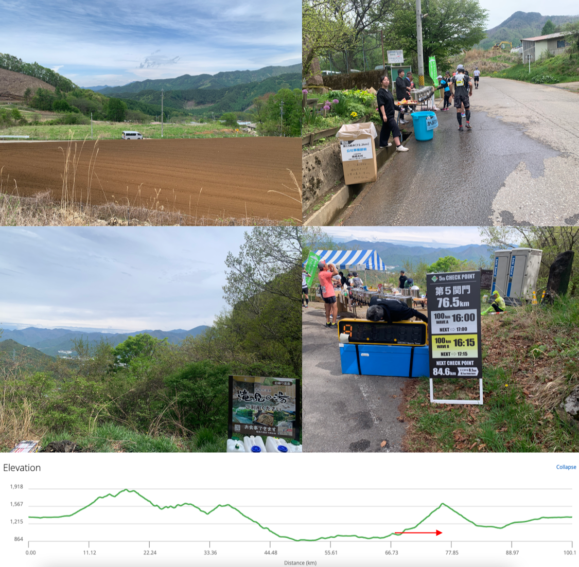
The clock wasn’t working but according to the time I took the picture I arrived at the fifth checkpoint (馬越峠 : Magose Pass) at 14:03, meaning I was still about 2 hours ahead of the closing time.
Checkpoint 5 to Checkpoint 6 (76.5 – 84.6 km)
川上村原公民館 : Kawakami-mura Hara Community Center
This section was FUN. I saw some runners walking out of the Magose Pass aid station and down the hill, but I was very much back in my element so I stated running. It was ALL downhill in this section. The roads were curving around farmland but it was all at a comfortable decline. I went from trudging up mountains to running at around 5 min/km for about 5 km.
I briefly stopped at an aid station on the way down, but as the road started leveling off my speed also started decreasing. I felt like I could walk pretty much indefinitely but my body started protesting when I needed to run. My foot was really hurting by now (earlier in the report I mentioned that I had some discomfort in my right heel. This had gone from discomfort to borderline pain).
At this point I was run/walking through 川上村 (Kawakami village) (the name was appropriate (literally above river) because a beautiful river ran through the area). The mountains in the distance looked absolutely stunning. I remembered from studying the course that once I hit this village and ran along the river for a bit I would end up at a community center and final checkpoint.
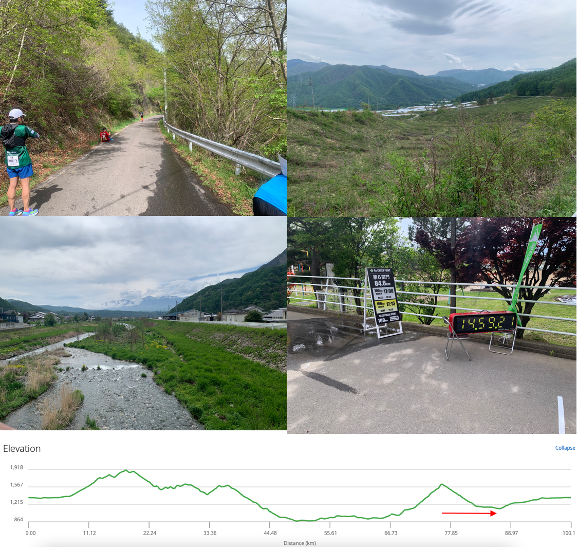
It was a slog to get to this area but I managed to reach the checkpoint (川上村原公民館 : Kawakami-mura Hara Community Center) by 14:59, two hours before it closed. This gave me 3 hours to cover the final 15.4 km to get to the goal.
Checkpoint 6 to GOAL (84.6 – 100 km)
南牧村社会体育館: Minamimaki Community Sports Center
I ate and drank what I could at this aid station then started do run/walk towards the finish line. Checkpoint 6 was an important checkpoint for me because I knew that once I reached there it was pretty much impossible to DNF. I could walk the whole way and still meet the cutoff. Still, I wanted to do my best to get the best result that I could get.
I was picking walls, lamp posts, buildings, etc as reference points and running between them. At one point an older guy with a black bib ran by me and gave me some encouragement in English. “Not much further. Keep going.”
Once I got to the 90.5 km aid station I felt like I was making good progress. Every kilometer feels like a bigger achievement when you’ve only got about 10 to go.
At this aid station an elderly gentleman looked at me and asked me if I remembered him. I was not fully with it at the time, but he said, “You gave me a high five at the beginning of the race.” Once he said that I did remember him. I thanked him for coming out and showing support all day. This was actually one of the highlights of this race for me.
After refueling and run/walking out of that aid station I ended up meeting that runner with the black bib that spoke to me in English. He told me his name was “Nori” (clearly a nickname) and once I told him I was from the UK he started telling me about how much he loved the UK (despite never having been there) and talking to me about music. It was a really nice interaction.
At some point we got separated (either he went ahead or I went ahead of him) but it was clearly around one of the last hilly sections of the course. (Final boss time).
Another dude started running with me sounding like he was about to pass out. I told him a few times to take it easy because it would be a shame to pass out and DNF so close to the finish line.
I ended up not stopping at all at the 94.5 km aid station and just kept on run/walking at this point. There was more walking than running going on, but at one point I saw a race photographer and decided to pick up the pace. (I didn’t purchase race photos but I did see that picture. I’m happy I didn’t look like death at that point).
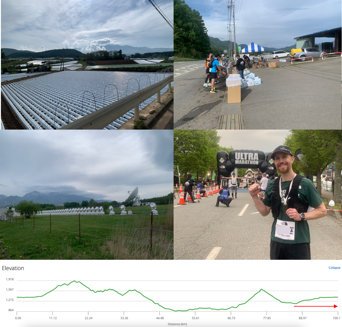
The final ‘obstacle’ of the race was the 国立天文台 (National Astronomical Observatory of Japan). (I could occasionally hear the announcer at the finish line around here so I knew I was getting close to the end). The whole area was filled with radio-telescope dishes. It was a really cool area to run through. The course had been changed slightly this year to allow runners to go through this area. It was a good choice.
After I left the observatory park I saw a marker with “1 km to go on it.” I was suffering at this point and wanted the race to be over, but I didn’t have a full 1 km sprint in me so I walked until I found the opportunity to break away.
Once I saw the final corner before the finish line I broke into a run, ran through one of the tracking sensors, then heard the announcer welcome me back by name. I slowed down a little bit to let the runner in front of me have their moment of glory, and then I charged through the gate to finish off this epic journey.
After the race
Right after going through the gate a volunteer put a finisher medal around my neck. I was feeling pretty emotional at that point but I held everything together. (Not sure why I get like this after some ultras but not others).
I handed in the race chips on my shoes and as I did one of my friends who I run with regularly came up to me and congratulated me on my finish. He is much faster than me and had finished quite a while before me.
I also ran into the giraffe runner again. Turns out he was hitting up the hot springs as he was running around and still managed to finish with a time similar to me.
I ate some food at the finish line (more noodles), and then walked back to the train station where I was picked up and taken back to my hotel.
One of the first things I did when I got back to the hotel was hit up the hot spring. Bathing after an ultra is a great way to find out where your injuries are. My right heel was a bit of a mess. I’ll spare you the details but I had a large split across my heel that I became VERY aware of when I put my feet in the water.
After bathing I tried to eat dinner (only managed to eat half of the food) then pretty much collapsed.
I woke up the next day feeling a bit sore but very accomplished. I set off home (a 4 hour journey), and thoroughly enjoyed the opportunity to sit down and watch the world go by the train windows.
Race Results
The final race results have not been announced yet. I will update this article when I have the data.
My finishing time was 12:25:30 according to the official clock (which was more or less the same as my watch time).
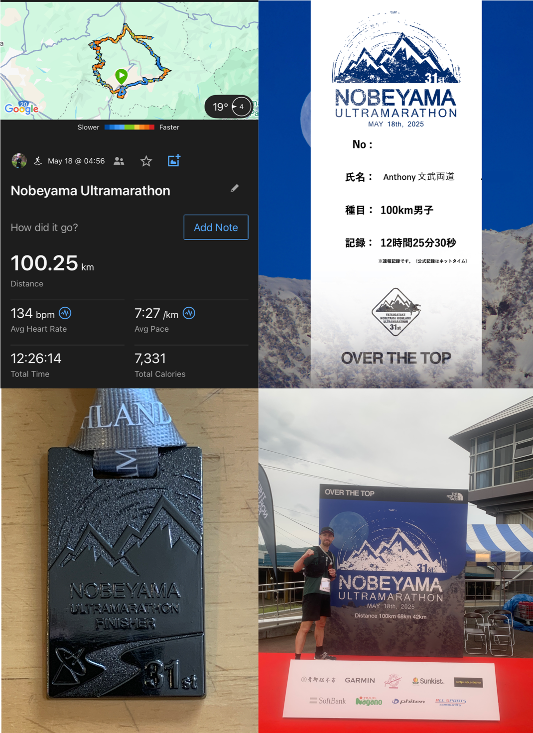
According to the Nobeyama Ultramarathon website, the completion rate for my division (100 km men) was 62.6%. (1,057/1,688). The overall completion rate across all divisions was 65.5% (1,756/2,681).
Final Thoughts
Before entering the Nobeyama Ultramarathon I had no understanding of its grueling reputation. When I looked at three of my previous races I thought I’d be ok:
Challenge Fuji 5 Lakes (118 km, 973 m) - Longer race. Same organizer
Yagurazawa Ōkan (160 km, 2,598 m) - Much longer race, similar elevation
Izu Trail Journey (70 km, 3,242 m) - Much more elevation
The things that made Nobeyama stand out was that it is 100% road, the cutoff times were strict, and the placement of the climbs and descents made your pace difficult to manage.
When you run on trails you tend to use different muscles as you traverse the technical terrain. A 100% road run has you using the same muscles for every step. The cutoff times paired with how difficult it was to predict pace put constant pressure on you to keep the pace up (even when you should probably be slowing down). If I was unable to run all the downhill sections of this I probably would have struggled to make the cutoff times.
There is a phrase associated with the Nobeyama Ultramarathon.
「野辺山を制するものは、ウルトラを制す」
“Whoever conquers Nobeyama conquers ultra.”
On some levels I’m glad I didn’t know that before I entered. I didn’t know about that phrase or the fact that people call this race the 東の横綱 (Higashi no Yokozuna). Yokozuna is the title given to the highest ranking (strongest) sumo wrestler, so the race is colloquially called the “Strongest in the East” due to its difficulty. (Note that there is a Yokozuna in the west too. 西の横綱 (Nishi no Yokozuna) is a 100 km race with 3,000 meters of elevation held in Hyogo Prefecture in September called the 村岡ウルトラマラソン (Muraoka Ultramarathon). Maybe something to consider in the future).
I’m very much looking forward to my next opportunity to do something like this again. This was a lot of fun.
Thank you
Thank you very much for reading. This was a long one. I hope that my experience with this race will be useful for people who want to take on the Nobeyama Ultramarathon in the future.
If you enjoyed my writing please consider subscribing for more content like this.
