7th Aobato Trail Run (Oiso to Oyama)
Typhoons, and leeches, and bears! Oh my! : Race report 9
青鳩トレイルラン第7回大会(大磯~大山): 7th Aobato Trail Run (Oiso to Oyama) : 24 September 2022
Background
In 2021 I ran my first marathon and my first ultramarathon. Both of these runs were done on roads and I really wanted to do a trail running event to diversify my running experience. After searching around for some time I came across a local event called the 青鳩トレイルラン (Aobato Trail Run). If we want to get technical the race name is the ‘White-bellied green pigeon’ trail run in English but I’ll just call it it the, “Aobato Trail Run” to keep it simple.
What I knew about the race when I first signed up on Runnet was that it was a 30 km trail run from 照ヶ崎海岸 (Terugasaki Coast) in Oiso (0m) to the peak of 大山 (Mt Oyama) (1252 m) before heading down to the クアハウス山小屋 (Kurhaus Mountain Hut) (312 m). I may have been a bit unprepared or the course when I signed up but after a bit of online research and also going on a road trip to the finish line, I realized that the course would be a bit more involved than simply running up and down a single mountain and I would be contending with leeches, and possibly even bears during the run.
The course map can be found here on Yamap but everything is in Japanese. Briefly, the checkpoints on the course that needed to be followed were:
照ヶ崎海岸 (Terugasaki Coast) (0m) - Start
鷹取山 (Mt. Takatori) (219m)
権現山 (Mt. Gongen)(243m)
弘法山 (Mt Kobo)(235m)
高取山 (My Takatori(different kanji to the one above))(556m)
浅間山 (Mt Asatama)(679m)
イタツミ尾根 (Itatsumi Ridge)(1150m)
大山 (Mt Oyama)(1252m)
クアハウス山小屋 (Kurhaus Mountain Hut) (312m) – Finish
Before the race (Everything goes wrong)
The race was the end of September which can be a bit hit or miss when it comes to the weather. It’s usually hot, but getting cooler which causes the formation of typhoons around the sea of Japan. Right before the race a typhoon decided to land right on top of Kanagawa prefecture, which made me think the race might be called off.
I checked the organizer website the day before and there was an announcement that the course was going to change. It was decided that it was too dangerous to go all the way to the top of Mt Oyama so the organizer changed the route a little so it would be less lethal. Originally after hitting checkpoint 4 (蓑毛越 : Minoge Pass) the plan was to go to the summit of Mt Oyama but instead the new route took us on a detour past (下社 : Shimosha) then on to checkpoint 7 (見晴台 : Miharashidai). None of this meant very much to me at the time because I was focusing on the extremely heavy rain that was battering my house.
The thought of running in this kind of weather meant I had a very bad night’s sleep and quite a lot of gastrointestinal disturbance due to worry. Thankfully I had some medicine on hand to settle my stomach, but it was bad enough for me to think that I wouldn’t be able to attend the race. In the morning I was up at 6am, I checked the website (no further updates), ate a light breakfast then headed over to Oiso.
Race Start
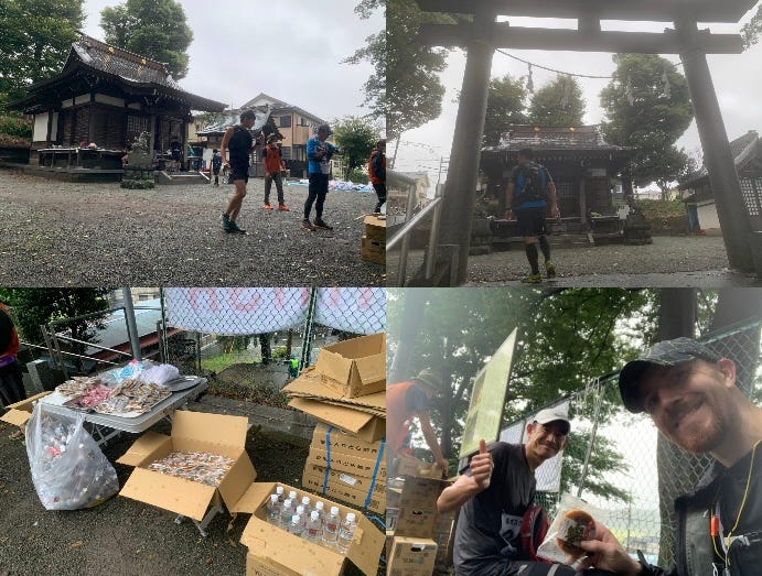
I arranged to run the event with a fiend of mine I met during my first ultramarathon (T-San). If I hadn’t have arranged to meet my friend I may have lost my nerve and not entered, but I didn’t want to let him face that typhoon alone. We met on the train and headed down to the coast together. When we got there we checked in, dropped off our bags and received our finger mounted race chips. In this particular race, when you hit a checkpoint you needed to insert the chip into a socket until it made a beep and then you could continue on your way. It was quite a satisfying way to log progress but it was a bit more time consuming than simply running over a sensor plate.
After checking in we went over to the start line. A lot more people than I expected showed up but part of that could have been because I didn’t count the B course people. The A course (my course) was 30 km and limited to 300 participants (189/300, 63% attendance) plus the additional people who signed up for the B course (43/81, 53% attendance). The organizers led some radio exercise and then got everyone set up at the starting line to leave in waves of 50 people according to their numbers (thankfully T-San and I were in the same block).
The announcer was supposed to set off every group using a starting pistol but the typhoon must have completely drenched the gun so it only worked sporadically. He chose to use a whistle instead of shouting ‘bang’ but that was good enough to get people moving.
照ヶ崎海岸 (Terugasaki Coast) 0m to Takatori Shrine (鷹取神社) 219m
The course started out almost like a road race. It was very flat…until it wasn’t, and then it was uphill. Pretty much as soon as the uphill part started the pace started slowing down. The hill at the start seemed kind of steep but little did I know that some of the later hills would make these ones look like an absolute joke. The path also started getting quite narrow here so everyone needed to go in single file.
We ran through some farmland and through some tunnels but then then things started getting even steeper than before and everyone slowed down even more. The first checkpoint was at Takatori Shrine which was around the peak of Mt Takatori at 219 meters. We punched the chips at the checkpoint and moved on
Takatori Shrine (鷹取神社) 219m to Takehaya Shrine (健速神社) 61m
After leaving Takatori Shrine there was a sudden wet and muddy descent where it was absolutely not safe to take pictures. A lot of the course could have been more accurately described as a stream than a trail and I ended up completely covered in mud. That might have been a bit off-putting but I was already completely drenched so no real issues. We crossed over some more farmland, got to quite a flat area for a while and passed by a pretty fierce looking river on the way to the second checkpoint at Takehaya Shrine. We had descended pretty far at this point and were running next to a river so this part of the course was very flat.
Takehaya Shrine was the first aid station on the course. Dorayaki (a kind of pancake snack), umeboshi (pickled plumb), and water were the main things on offer at the aid station, and were very welcome. This aid station was just under 13 km into the course and although it was fun I’d say about 50% of it was on the road. I would not have been satisfied to stop here so I was glad I had more trail to explore.
Takehaya Shrine (健速神社) 61m to Mt. Gongen (権現山) 243m
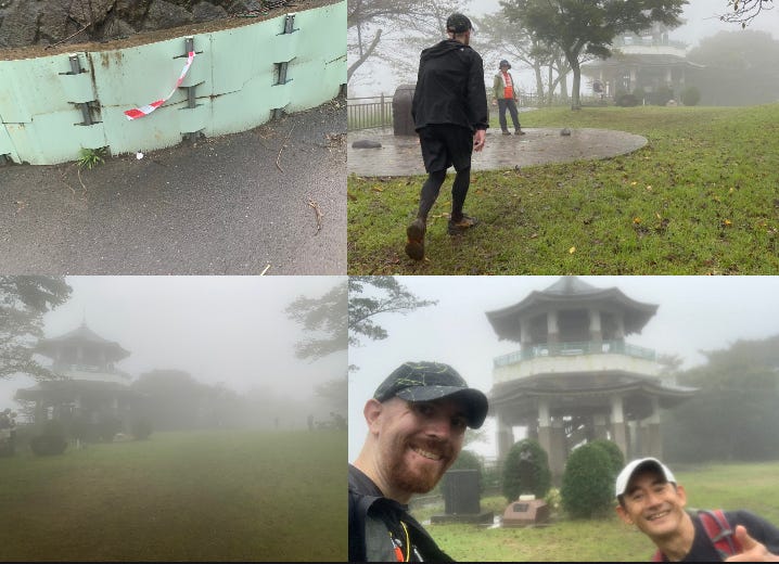
It was at this point that the runners started getting less bunched up. Some of the faster people had already run ahead and others were leaving the aid station at their own pace. Up until this point it was easy to figure out where we were going because the people in front of us were like course guides. At this point we could see some people in the distance but we needed to rely more on the course markers (and any locals that were out cheering the runners on) for directions. The course markers were these pieces of white and red tape that were not exactly easy to spot. I brought a paper map with me, which was completely useless but T-San had the GPX data on his watch. Between the course markers, the GPX data and the occasional glimpse of a runner up ahead we managed to find our way. The next section had us running through farmland and then into gradually more steeper trails.
When we arrived at Mt Gongen there was an observation tower but the fog meant that there wasn’t a great deal that we could observe. It was kind of nice in its own eerie way. There was a park, an observation area here but that’s about all I could see.
Mt. Gongen (権現山) 243m to Mount Kōbō (弘法山) 235m
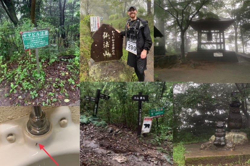
We set off up the trail and found a sign for the next area (Mt Kōbō). It seemed like there were a few parks in this area so it wasn’t like a regular trail. It was possible to come across the occasional vending machine and the occasional public toilet. Toilets and vending machines were very few and far between on this trail run so it is a good idea to use them when you see them. The ones in this particular area had a bit of a leech problem so in very damp conditions like this trail run we were on I wouldn’t necessarily recommend using these (especially when your main anti-leech device is a lighter). There were a few nicer toilets a bit further on but these were the last we saw for a long while.
The next part of the trail was not too bad. Not much climbing or descending. We passed some statues, passed some nicer toilets, and reached a shrine with a large bell. This was pretty much the last piece of civilization for a while. If you run this trail it might be worth considering the last shrine a point of no return so if you need supplies or need to use the restroom, use the vending machines and toilets around here.
Mount Kōbō (弘法山) 235m to Nenbutsuyama (念仏山) 357m
It was right around here where things started hitting what I would consider to be wilderness areas. It was all trails with no roads to be seen. There was some descending followed by a lot more ascending and even the occasional sign warning you of bears.
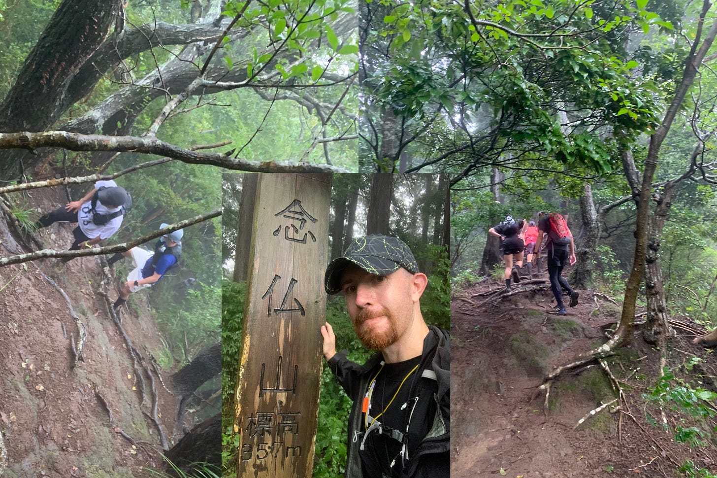
By the time we hit found a sign for Nenbutsuyama (念仏山) we had been climbing for quite some time. It was unbelievable that we had done so much climbing and then found a sign that we we were only 357 m above sea level. Little did we know that the next section of the trail was much steeper and made the current section look quite flat.
Nenbutsuyama (念仏山) 357m to Minoge Pass (蓑毛越) 686m
It was about at this point that I started questioning my life choices. The picture I took do not do justice to how steep this area was. Most of this area was a combination of climbing up steep hills and tree roots. It was not possible to run in this area. It was just climbing. It was not exactly safe to take pictures in these areas so only took a few before the ground started leveling out again. In this area it was taking about 17 minutes to cover a single kilometer.
It leveled off a bit after this (and by level off I mean there was some gradual ascents that didn’t involve climbing) followed by climbing sections. There were a few descents around here were it was possible to run for a bit and it felt good to do that just to loosen my legs. We took occasional breaks to drink water but I had pretty much emptied my water bottle and was wishing that I’d used one of the vending machines we came across in the parks an hour or so back.
There were no obvious landmarks in this area but all of a sudden we hit a point in the trail where we could hear someone shouting and generally making a wild commotion. I thought someone had fallen and was shouting for help so we picked up the pace a bit to see what was wrong. When we managed to see what was going it turned out we were getting close to a checkpoint and one guy was shouting and screaming for everyone to run to the checkpoint. As we were running towards the checkpoint (and aid station) it turned out that the reason for such a commotion was to get people fired up to take some race photos. Those photos ended up being really good.
The aid station was exactly what needed at that point. I don’t remember eating anything but I managed to down a full 500 ml bottle in a few seconds and refill my own water bottle. There staff had set up a tent and were giving out noodles to the runners but I wasn’t really in the mood to eat anything and just wanted to move on to the next checkpoint. The original plan was to go from here to the peak of Mt Oyama but the typhoon had made it necessary to change the course. This course change turned out to be quite nice.
Minoge Pass (蓑毛越) 686m to Afuri-Jinja (阿夫利神社) 695m
The alternate route had us going along an interesting hiking trail. The scenery was stunning around there and there were a few interesting obstacles including a section where we needed to use a chain to climb a pretty steep section. Hiking this area was advised because falling would have been a problem.
Towards the end of this trail area we could hear a cable car docking into a station. We didn’t actually see the station but we knew that there was a station at Afuri-Jinja (Jinja means shrine) which was the next checkpoint. It wasn’t really possible to see very far from this shrine due to the fog and the rain but that kind of made the atmosphere a little more mystical.
Afuri-Jinja (阿夫利神社) 695m to Miharashidai (見晴台) 763m
Right after the shrine there was a staircase that led to a store which was selling things like hot and cold drinks, ice creams, noodles etc but we decided that it wasn’t that far to the end and if we stopped now it might be difficult to get going again.
The next area was very similar to the hiking trail from Minoge Pass to the shrine only with more signs telling you to watch your step and be careful of falling rocks. It was very picturesque with a lot of waterfalls. This was all part of the detour route due to the typhoon so I’m not sure if this part of the root is going to be in a future event of this kind. I do know it will be very nice to hike up here.
We eventually got to the final checkpoint before the finish line. It was a little underwhelming. All that was there was a few benches, a puddle and some staff who checked us in and told us there was about 2.8 km of the course remaining.
Miharashidai (見晴台) 763m to Kurhaus Mountain Hut (クアハウス山小屋) 290m
I didn’t take any pictures of this part of the course because I think it could have been the most dangerous area. We knew that the end of the course was less than 3 km away but what I didn’t know was how much of a descent we had in front of us. Miharashidai was at 792.9m and the finish line was at 290.02m meaning we were going to be descending 472.88m very quickly. We started descending down some quite large stairs at first followed by running along a kind of board walk system. T-San was ahead of me and is a little shorter than me so he kept running under branches that were exactly at my head height meaning I took a few branches to the forehead on the way down. After the board walk we had a muddy, rocky, root filled, zig zag course to descend. Watching some of the advanced trail runners go down this area was incredible. I was definitely not comfortable doing downhill that fast so T-san and I descended as quickly as it was safe to do so.
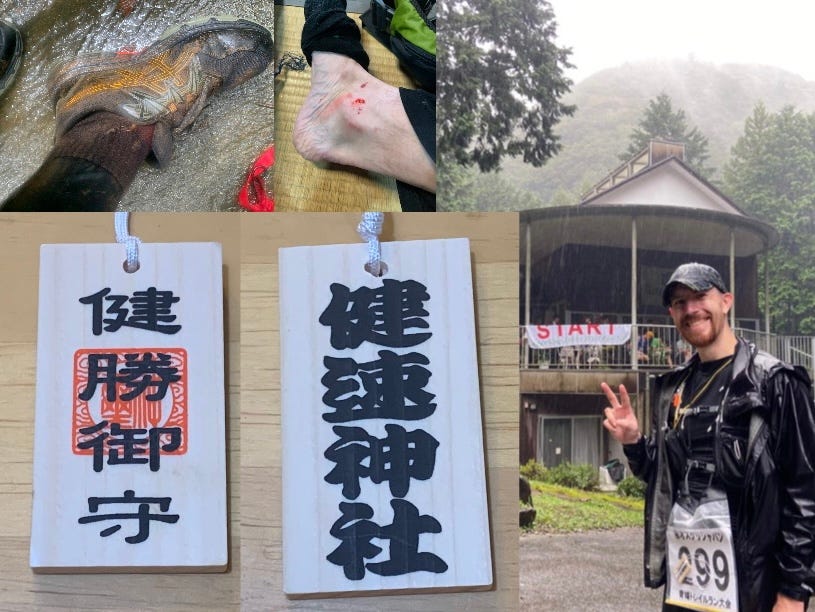
I had been to the finish line before so when I knew we didn’t have long to go and no more obstacles so we just ran down the road and got to the finish line. I’m not sure why the organizers put the start banner at the finish line because it’s a bit misleading but at this point we didn’t care and were just really happy to have finished the course.
The aftermath
It’s only when you stop that you realize how messed up things were. Quite a few people were hosing off their muddy clothes but there were also quite a few people with quite serious leech bites. Quite a few people were not wearing leggings or long socks so they had a lot of bites. I found out that I had a few passengers that had managed to bite through my socks so even though I didn’t have any exposed skin I was still a meal for a few leeches (which I burned off with the lighter I brought with me).
The mountain hut had a shower and a bath which was very busy at the time. Leeches were also being brought in on people’s clothes so there was no escape from them. I was quite happy to get changed but in hindsight I should have left an extra set of shoes in my drop bag because all I had with me was some fresh socks. Those socks were not fresh as soon as I put my shoes on because partially waterproof shoes are good for keeping water out and water in.
We were provided with some udon (which was great after a long race) and were then taken to Isehara station by bus. When we got off the bus the driver told us to head left to get to the station. T-san and I joked that one final trick that should have been done by the event organizers would have been to put that white and red tape in the direction of the station.
Race Medal
This race didn’t have a medal but at the finish line we were given an amulet from Takehaya Shrine (which if you remember was the end of the B course). The charm has the shrine name on one side and on the other says 健勝御守(けんしょうおまもり : kenshou omamori) which translates as ‘Amulet of Good Health.’ The gods help those that help themselves so if you are able to complete this race I think you’ve earned your amulet.
Race Results
I received my completion certificate through the mail with the official time adjusted results. My official time was 4 hours, 43 mins, 27 seconds, I was 17th out of 18 in my age category (yikes) and I was 103 of 172 in the overall mens category. My aim in entering this race was just to finish my first trail race and I’m very happy that I was able to complete this.
Final thoughts
This trail race was my first real trail run experience outside of running around a mini trail in my local park. I kind of threw myself in at the deep end with this one but I have absolutely zero regrets. It was a lot of fun and I would like to do something like this again. I know now that I can run a pretty ambitious trail race in a typhoon with zero experience and not only survive but have fun doing so.
If I were to do anything differently I’d bring extra water with me. I packed more food than I needed but no emergency water. It is possible buy more water from a vending machine on the way but if you want to do that you have to do so before you leave the Mt. Gongen (権現山) to Mount Kōbō (弘法山) area.
I would like to thank the race organizer, the Outdoor & Nature Experiences Promotion Institute NPO (website here (Japanese only)), the cameraman at the Minoge Pass (蓑毛越) checkpoint for the amazing shots (Yousuke Kato Photography), my friend T-San for running the race with me, and also all of my supporters who have taken their time to read this report.
Thank you very much for reading. If you enjoy my work please share it with someone you think would also enjoy it.
If you aren’t subscribed, please sign up to keep up to date.
If social media is more your thing I’m active on Facebook, Twitter, and Instagram.
And if you are looking for ways you can support my work please check out the page below:
Osu!
Anthony


